Wiltshire Council has used connected vehicle data to investigate reports of drivers failing to give way at a junction in Westbury, enabling engineers to identify and address the underlying cause before collisions occurred.
The authority analysed three years of data supplied by Compass IoT to examine driver behaviour at the junction of Trowbridge Road and Bratton Road, where residents had raised concerns about motorists not slowing or stopping as required.
The connected vehicle data, collected anonymously from vehicles already travelling on UK roads, provided detailed information on speeds and braking behaviour at metre-by-metre intervals.
Analysis showed that average speeds on Bratton Road – the priority route through the junction – remained broadly consistent between 2024 and 2026. However, the proportion of westbound vehicles exhibiting harsh braking increased from virtually zero in 2024 and 2025 to 16% in 2026, with a further 3% of eastbound vehicles also recording harsh braking.
On Trowbridge Road, the data revealed vehicles accelerating through the junction, with a wider spread of northbound speeds than in previous years. Harsh braking also increased significantly, rising from 5% to 21% on the northbound approach and from 3% to 22% on the southbound approach over the same period.
The findings suggested a growing conflict point at the junction.
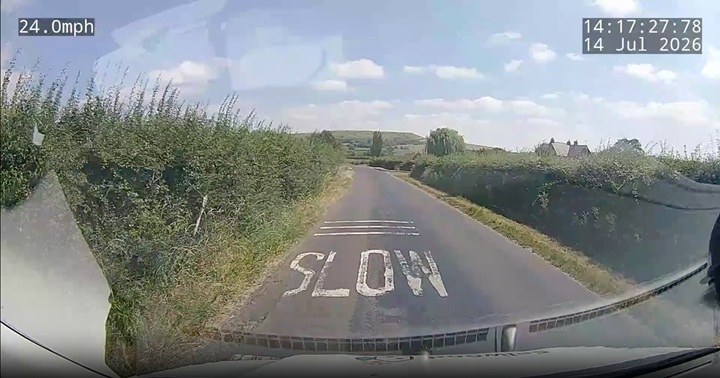
By combining the vehicle data with imagery captured by connected vehicles, engineers identified the cause of the problem. Comparison of images from 2024 and July 2026 showed that roadside vegetation had become overgrown, restricting visibility of oncoming traffic at the give-way point and obscuring road signs.
Following the investigation, Wiltshire Council trimmed the vegetation, restoring sightlines and improving the visibility of the junction.
Gareth Rogers, traffic engineering manager at Wiltshire Council, said: “Using this type of data allows a different insight into understanding the issues motorists encounter on the network.”
He added that the information provided engineers with a clearer understanding of driver behaviour and the factors contributing to the reported concerns.
Traditionally, local authorities rely on resident reports, STATS19 collision data and site visits to identify emerging road safety issues. Wiltshire says connected vehicle data can provide earlier evidence of changing driver behaviour, helping engineers identify potential risks and implement interventions before collisions occur.
Compass IoT says the approach enables authorities to monitor how motorists interact with the road network remotely, reducing the need for repeated site visits while providing time-stamped evidence to support targeted safety improvements.
According to Google Maps, Trowbridge Road doesn’t seem to be near Bratton Road in Westbury, let alone have a junction with it – can anyone clarify please?
Hugh Jones, South Wirral
0